The Aral Sea
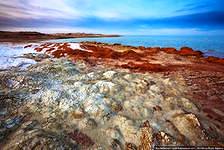
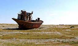
Muynak The Aral Sea – closed salt lake in Central Asia, it is situated on the border between Kazakhstan and Uzbekistan. Before the beginning 1960, it was the fourth largest lake in the world. The inflow of water in the Aral Sea is provided by the rivers Amudaryaand Syrdarya. Because of human activities, Amudarya and Syrdarya are used for agricultural purposes. At the beginning of XX century water flowed thanks to groundwater and precipitation.
Before the drying of the Aral Sea, there were 20 species of fish, 12 species of worms, 9 species of mollusks, 33 species of crustaceans. Since 1974, the drying of the Aral Sea has accelerated, as well as sharply reduced water flow. From 1982 to 1985 it almost didn’t get the water from the rivers. In 1989 the pond was divided into Large and Small Aral.
Small Aral Sea was created in 1989 after the drying Berg Strait. By the end of 1992 the strait was 2 metre in depth, 100 metre in width and 5 km in length. In the same year, Berg Strait was closed by earthen dam. After this, the water level of the Small Aral Sea was increased. Gradual recovery of flora and fauna was begun. Because of the lack of culverts, dam was often destroyed. In 1999 it was destroyed by the storm. The water level in Small Aral was dropped. In 2004 a new dam with culvert was built in the Berg Strait. In spring 2006, water reached the planned level.
Large Aral Sea is not in a favorable condition as the Small Aral Sea. After the construction Kokaral dam, dryind of Large Sea was intensified as the flow of water from Syrdarya was stopped. In 2010 the Big Aral Sea again was filled with water from the Amu Darya. But because of dry summer of 2011, Big Aral Sea was increased in size.
Drying up of the Aral Sea had serious consequences. Despite the extensive catchment area, currently the Aral Sea doesn’t get the flow of water from the Amudarya and Syrdarya.
